There are two types of background maps: Images() and Boundaries(). Each of these takes a parameter, which is the name of the map to use. The name is one of the maps listed in the window.
|
•
|
For Images(), the choices are Simple Earth, Detailed Earth, NASA, Street Map Service, and Web Map Service. If you use Web Map Service, then there are two additional parameters: the WMS URL and the layer supported by the WMS server.
|
|
•
|
For Boundaries(), the choices vary since boundaries can be user-defined. A typical choice is World.
|
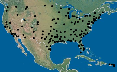
dt = Open( "$SAMPLE_DATA/Air Traffic.jmp" );
dt << Graph Builder(
Size( 1101, 603 ),
Show Control Panel( 0 ),
Variables( X( :Longitude ), Y( :Latitude ) ),
Elements( Points( X, Y, Legend( 8 ) ) ),
SendToReport(
Dispatch(
{},
"Graph Builder",
Frame Box,
{Background Map( Images( "Simple Earth" ), Boundaries( "World" ) ),
Grid Line Order( 3 ), Reference Line Order( 4 )}
)
)
);
Figure 12.31 shows an excerpt from the map:
Figure 12.31 JSL Scripting Example
Background Map ( Images ( "Web Map Service", "http://sedac.ciesin.columbia.edu/geoserver/wms", "gpw-v3:gpw-v3-population-density_2000" ), Boundaries ( "US States" ) )
To see which layers are available on a WMS server, install the WMS Explorer Add-In. Download the add-in from the JMP File Exchange at https://community.jmp.com/docs/DOC-6095. Note that some WMS servers are not reliable. If the server is down, or if the user does not have an Internet connection, the WMS map does not appear.
|
•
|
To see the syntax for the JSL script, add a background map through the user interface. Then from the red triangle menu, select Save Script > To Script Window to see the script that is generated.
|
|
•
|
|
•
|
Look at sample data to find examples of background map scripts. Select Help > Sample Data Library and open Napoleons March.jmp, Pollutants Map.jmp, or San Francisco Crime.jmp. Right-click the map table script and select Edit to see the Background Map() function.
|